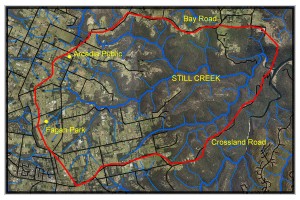
Catchment map
Creeks
The catchment area is 1800Ha and includes Still Creek and its tributaries Halls Ck, George Hall Ck and Charltons Ck.
The catchment waters flow into Berowra Creek at Crosslands and thence into the Hawkesbury River, which is used for oyster farming, recreational fishing, swimming and other activities. Gradual siltation of Berowra Creek has been observed for some decades.
Ownership
This area is comprised of approximately:
- 65% private property (approximately 420 residences), council properties and roads, centred mainly on the ridges but covering all creek head waters.
- 32% Berowra Regional Park, administered by DECC, centred mainly around the creeks downstream.
- 3% Fagan Park with bushland and mowed grass areas.
Approximately 50% of the area has native tree cover, centred mainly on the creeks.
Geology
The ridge tops along much of Crosslands, Knights, Arcadia and Bay Roads are clay soils based on Wianamatta Shales. These flat, rich soils are suitable for farming. The lower strata are mostly Hawkesbury Sandstone with steeper, rougher, low nutrient soils and much of this remains undeveloped bushland.
Species Diversity
The Hawkesbury sandstone has some of the richest flora diversity in the world.
The catchment contains 7 threatened Plants and 10 threatened Animals including the Powerful Owl and the Red Crowned Toadlet.
A survey of the catchment has been carried out and a plan for the catchment is available.


